
CA
Due to the COVID-19 Pandemic this Website Presentation or “Virtual” Open House for the Beechwood Specific Plan Project (BSP) has been put into an interactive website and web mapping application. In the collapsible sections below you will be able to read information about different key components of the BSP and click the associated images to view them in full size.
The Transportation/Traffic section contains an interactive map that will allow you to visualize some of the planned projects and improvements that will be made as a result of the BSP.

Clicking the image above will take you to the Transportation Improvements Map
Comments can be submitted in the contact form at the bottom of the page.
This Website Presentation or “Virtual” Open House for the Beechwood Specific Plan Project (BSP) has been prepared solely by the Applicants of BSP. It has been prepared to provide the public updated information about the project since the initial Open House was held in May of 2018. Because of the COVID-19 Pandemic, the Open House is being presented by way of the internet so that social distancing requirements can be maintained.
Since the first Open House, the Project has undergone a thorough review by the City resulting in a number of design modifications and enhancements, as well as modifications found necessary by the Project’s Draft Environmental Impact Report (DEIR).
This Presentation is organized around key components of the Project as well as issues that were communicated to the Project team during the first Open House.
Recognizing that not all the Project’s information is provided in this presentation, it is recommended that you utilize the links provided at the end of the website presentation to review the complete BSP document, including its appendices, and its DEIR. You are invited to make comments on the BSP on the city’s website.
Advertised Public hearings before the City’s Planning Commission and City Council will soon be scheduled for which interested parties will be noticed.


The Beechwood Specific Plan Project is located along the east side of Beechwood Dr., between Meadowlark Rd. and Creston Rd. in southeast Paso Robles. Unincorporated San Luis Obispo County borders the Project on the southwest and east boundaries.
Virginia Peterson Elementary School is located adjacent to the site at Beechwood Dr. and Meadowlark Rd.

- The BSP Project Area includes six different ownership interests and totals 234 acres, including 23.8 acres within the existing PG&E Power Line Easement. No development is proposed within the PG&E easement.
- The site was annexed to the City in 2004. It was authorized for development of 911 units of both single family and multi-family dwellings and 40,000 square feet of commercial space by Council action during the 2003 General Plan Update.
- The owners have been actively working together to create the development plan for BSP.

The Plan Area is composed of gently rolling terrain that is divided by a west to east trending ridge that runs through the middle of the property. This ridge divides the watershed with the northern half of the site draining northwesterly along Meadowlark Rd. just west of Oriole Wy. and the southern portion of the site draining to the southwest corner at the intersection of Beechwood Dr. and Creston Rd. In several areas of the site, isolated areas of wetlands occur within the two drainages described above.
There are currently six occupied residential units, a barn and several agricultural out-buildings. The property is planted with forty acres of grapes and the balance of the undeveloped area rotates between grazing and grain farming.
There are 100 mature, native oak trees on the site with the majority of the trees located in the central portion of the Plan Area.
See the image below for the Plan Area’s topography and other existing conditions.

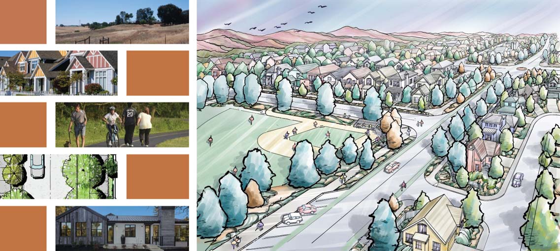
Careful consideration has been given to streetscapes, particularly along the perimeter roadways. Wide parkways and abundant landscaping will provide those traveling the roadways a pleasant experience, like the view to the right of east bound Meadowlark Road, just east of Beechwood Drive.


Roads that are interior to the project, or local roads, will include tree-lined sidewalks with enhanced water quality basins or other park-like features at key intersections to add interest to the residential neighborhoods.
The 8-acre Beechwood Community Park will provide abundant and nearby recreational opportunities to the neighborhoods of the Beechwood Specific Plan.

The Beechwood Specific Plan envisions an interconnected network of active mobility facilities including multi-use trails, bike lanes and sidewalks, with a roadway network incorporating the latest in traffic calming strategies.
An interactive map has been developed which illustrates the various onsite and offsite transportation improvements to be implemented by the Project; please click here to access the map.
The project includes the below main transportation categories which can be expanded for more detailed information.
Artist’s Rendering of Meadowlark Road Looking East from Beechwood Drive
- Meadowlark Road
- Traffic Calming: Narrowed lanes, mini-roundabouts at Oriole and Deer Springs
- Beechwood Drive
- School Safety: Narrowed lanes, bike lanes; multi-use trail, sidewalk bulb-outs, crosswalk safety enhancements
- Airport Road
- Extends road south to Creston Road per General Plan Circulation Element
- Creston Road
- County road, multi-use trail, bike lanes, gateway treatments
- Ridge Road
- Internal collector, narrow lanes, bike lanes and multi-use path. No driveways. Traffic circle or mini-roundabout intersections for traffic calming.

The evaluation of project traffic impacts is summarized in the Traffic Impact Analysis (TIA) prepared by Central Coast Transportation Consulting (CCTC), including intersections and roadway segments throughout the City of Paso Robles, Caltrans facilities (State Route 46 and US 101) and County roadways (Creston Road, South River Road, and Barley Grain Road). The full report is included with the project Draft Environmental Impact Report (DEIR) at this link: https://www.prcity.com/357/CEQA-Documents.
Improvements to mitigate impacts to existing intersections and roadway segments are identified in the TIA and summarized in the DEIR Mitigation Monitoring and Reporting Program (MMRP), with transportation impacts & mitigations excerpted here.
The MMRP includes the following improvements to be made by the project, with graphical depictions available at the map-based tool.
- South River Road/Charolais Road: Construction of a single-lane roundabout.
- South River Road/Riverbank Lane: Install two-way left turn lane.
- Creston Road / Stoney Creek Road: Install traffic signal.
- Creston Road / Meadowlark Road: Install traffic signal.
- Creston Road/Charolais Road: Install all-way stop control.
- Niblick Road / Creston Road: Intersection widening for additional turn lanes.
- Niblick Road/South River Road: Construction of southbound right turn lane and signal optimization.
- 13th Street/Riverside Avenue: Corridor signal optimization; overlap westbound and northbound right turn phases.
- 13th Street/Paso Robles Street: Corridor signal optimization; lengthen northbound right turn lane.
- 13th Street/Union Road/N. River Road: Corridor signal optimization; restripe southbound approach with dedicated right turn lane.
- Meadowlark Road – Restripe to add bike lanes west of Beechwood Drive.

The Plan prioritizes mobility and access for all transportation modes and abilities to achieve the community’s vision of livability, connectedness, and environmental sustainability. The figure below illustrates this vision, providing a connected network of trails with streets designed to accommodate the diverse needs of all transportation modes including pedestrians and bicyclists.
Illustrative exhibits of the Plan’s transportation elements can be found using the map-based tool at the bottom of this page, or by clicking here.
All the interior or local roads will include tree-lined sidewalks, some of which are widened to 8-feet and amply landscaped to encourage pedestrian usage. Roadways are slightly narrowed to slow speeds yet allow for parking on both sides.

Virginia Peterson Elementary School is located at the southwest corner of Meadowlark Road and Beechwood Drive. The project proposes to provide a safe walking route to school, and accommodations for vehicular drop/off and pickup. The following elements are included in the preliminary design of the Plan (graphical depictions available at the map-based tool at the bottom of the page or by clicking here.)
- Narrow vehicular lanes on Meadowlark Road and Beechwood Drive (10 foot preferred; 11 foot maximum).
- Add Class 2 bike lanes on all roads.
- Provide a multi-use trail on the east side of Beechwood Drive and south side of Meadowlark Road.
- Shorten pedestrian crossings at intersections by constructing bulb-outs.
- Provide safety enhancements at crosswalks including high-visibility pavement markings and signs with rectangular rapid-flashing beacons (RRFBs).
- Provide back-in angled parking on the east side of Beechwood Drive to improve safety for cyclists and users of the community park.


A Water supply Assessment (WSA) was prepared for the project to document the City’s existing and future water supplies for its service area and to compare these water supplies to the area’s future water demand, including that of the BSP Project. This comparison, conducted for both normal and drought conditions in five year increments over the next 20 years, is required for assessing water supply in accordance with state law. Conclusions from the WSA are as follows:
- The Project area relies on groundwater from onsite private wells which will be abandoned or taken over by the City for municipal use.
- The BSP Project will use an estimated 263 acre-feet-per year at full buildout.
- City water supplies exceed the supply shown in the 2015 Urban Water Management Plan. The actual supply available to the City from the various sources is reflected in the blue numbers to the right of the table.
- The City has adequate and reliable long-term water supply in both non-drought and drought conditions to supply buildout conditions with the BSP Project.

- The City’s diversified water portfolio (consisting of the Salinas River, Lake Nacimiento, groundwater and recycled water) provides substantial drought resilience.
- In shorter term droughts Lake Nacimiento supply can play a key role in maintaining supply capacity. In addition to providing water for direct filtration in the water treatment plant, the lake water can be used to recharge the City’s river wells.
- If droughts are severe and occur over several consecutive years the City may have to implement the City’s Water Shortage Contingency Plan to reduce demands commensurate to any supply shortage.
- Current and prior City Councils have made solid plans for water supply, and the citizens have done a great job when conservation efforts were mandated by the State.
The BSP Project proposes a network of looped water mains to serve both potable water needs and fire demand. Water infrastructure improvements will include:
- Upgrades to existing 8” line in Beechwood Dr.
- New 12” lines in Airport Rd and Ridge Rd and portion of Creston Rd.
- Connection points to existing 12” line in Meadowlark Rd.
- All local residential streets will be served with 8” water mains
- The southeastern portion of the BSP Project area requires installation of a Pressure Booster Station to convert this area to a higher pressure zone.

The City is continuing work towards making re-cycled water available. The tertiary treatment plant necessary to supply recycled water is completed and online. The pipeline and pump system design is nearing completion and start of construction is awaiting funding.
The BSP Project will install recycled water mains for future use of recycled water in public landscape areas such as the community park, street parkways and medians. This will reduce project demand for potable water.

Provided below is a brief description of the proposed land uses and the associated density permitted for each. Each Land Use Category has a zone that is attributable to it and is indicated following the color noted on the Land Use Plan image that follows. These zones are further described in the slides that follow and will guide the future development of the BSP. The overall density of the BSP Project is 3.89 dwelling units (DUs) per acre (ac).
This is consistent with the zoning standard of the surrounding neighborhoods within the City.
- Residential Single Family – 7 (yellow: B-Residential Low) permits densities up to 7 DUs/ac and provides for lot sizes from 2,720 s.f. to 12,000 s.f.
- Residential Multiple Family – 14 (orange: B-Residential Medium) permits densities between 8 to 14 DUs/ac.
- Residential Multiple Family -24 (brown: B-Residential High) densities between 15 and 24 Dus/ac.
- Mixed Use – 24 (purple: B-Mixed Use) provides for 40,000 s.f. of neighborhood-serving retail uses. Additional residential units would be possible with a commensurate reduction of commercial space (1,000 s.f. of commercial space removed for each dwelling unit) if approved with a future amendment of the Specific Plan.
- Four different open space land uses are planned, including Community Park, Conserved/Natural Open Space, Amenitized Green Spaces, and the existing PG&E Utility Easement.
- See section 2.6, Development Potential, of the BSP and the image below of the Land Use Plan for details.

- The BSP Project is divided into 10
subareas. - Each subarea has been allocated a
specified land use and a maximum number
of dwelling units. - The community park has been designated
on all of Subarea G. - The 32 units allocated to Subarea G will be re-allocated equally between Subareas I and J.
- Subareas C-1, I-2, J-2, and J-4 each have
requirements to develop a minimum
number of Multi-family dwellings and
combined totals 150 units.

The BSP provides a brief description of each zoning designation, the permitted minimum and maximum density (du/ac) of each zoning category, and the gross acreage of each zone see Table 2.1 below.

The BSP Project is required to be consistent with the City’s General Plan, including the Land Use and Housing Elements. Thus these two elements have been instrumental in the development of the BSP. Listed below are five policies that influenced the design of the BSP, particularly with regard to providing a variety of housing types, providing housing opportunities to all segments of the community and helping the City accommodate its share of regional housing needs.
- Policy H-1.1 – Provide an adequate number of housing sites to accommodate the City’s share of regional housing needs and its special housing needs.
- Policy H-1.2 – Promote and expand housing opportunities for all segments of the community, recognizing such factors as income, age, family size, and physical ability. Integrate such housing opportunities in each neighborhood or planning area so as to avoid concentrations of any type of housing in limited areas of the City.
- Policy H-6.1 – Develop and redevelop neighborhoods and planning areas using compact urban forms that foster connectivity, walkability, alternative transportation modes.
- Policy LU-2D: Neighborhoods – Strive to maintain and create livable, vibrant neighborhoods and districts with: attractive streetscapes; a pedestrian friendly setting; coordinated site design, architecture, and amenities, adequate public and private spaces; a recognizable and high quality design aesthetic.
- Policy LU-2K: Support Environmental Responsibility – Manage the natural landscape to preserve the natural beauty and rural identity of the community, which enhances ecological functions and maintains environmental and public health.
In order to help meet the City’s need for housing, a wide variety of housing types for different income levels, market demand and price points is planned for the BSP. Multiple designs for single-family and multi-family homes are to be offered, providing opportunity to increase supply of workforce housing and help meet the City’s affordable housing requirements. Below lists the variety or housing anticipated by the BSP.
- Single- family lot sizes from 2,720 s.f. to 12,000 s.f.
- Duplexes, triplexes, fourplexes, townhomes and cottage court designs
- Multiple-family (Multiplex) condominiums and apartments units
- Traditional in the Variation of Housing Types Section, Variation of Housing types & Lot Sizes offered
- Design and Architectural Guidelines within the BSP and Appendix A of the BSP provide design guidance and provide character continuity within the community and ensures quality of final building product.
- Table 2-4 of the BSP summarizes the various housing types permitted in each Land Use Category.

- Different lot sizes and orientations to add interest and diversity to the housing products
- Small lot single-family house site plans. These examples show a lot size 34 feet in width and 80 feet in depth. As shown above, access can be from the front or front a rear alley.


- Cottage courts are small clusters of single-family homes arranged around a common open space or a shared driveway.
- In both cases, shared common open space is an essential feature of this building type.


- Townhouse development is an opportunity to establish an attractive and pedestrian friendly street wall.
- Whether front entries are located along a right-of-way (far left) or along a shared open space (left), the continuity of building facades lends character to the neighborhood.


- Small, house-scale multi-unit buildings contribute to a small-town feel while achieving moderate densities.
- The example site plans below show a shared driveway, separated footpaths and ample area for landscaping.

- Multiplex units are block-scaled buildings containing more than four units. The buildings present an opportunity to define the character of the block.


ADU Design Standards and Guidelines
- ADUs must be designed with colors, materials and forms consistent with the primary structure.
- Must have separate entrances to the interior.
- Design should have interesting roof forms, employ innovative design for compact spaces, and maximize light and ventilation.
- Ensure a safe path of travel between the ADU and the sidewalk or alley and be sensitive to the privacy of the primary structure and neighboring structures.
- These standards and guidelines are enforced through the development plans submitted to the City of review and approval.

The main Open Space and Recreation
features of the BSP Project include:
- An 8.1-acrea Community Park providing
active recreation opportunities. - Amenitized Green Spaces providing
passive recreation opportunities. - 2.9 miles of Multi-purpose Pathways
linking the Project’s neighborhoods and
amenity features. - Conserved areas of natural open space
for protection of wetlands and oak trees.

An 8.1-acre Community Park is provided in this BSP. Its location is conveniently located near Virginia Peterson Elementary School, easily accessed from Meadowlark Rd and Beechwood Dr., and situated on level terrain.
The Park Concept was reviewed by the Parks Committee and received preliminary approval to go forward with further design work. Key features of the Park include:
- Two baseball fields with an overlapping a soccer field and a separate multi-propose athletic field. One or more of these fields would be lighted for early night-time play.
- Two picnic areas, a tot lot, and parking along the park’s perimeter streets providing 121 spaces.
- A restroom and several shade gazeboes.
- Developers of the BSP Project are required to buy the land and construct the park improvements

The Community Park integrates into the surrounding neighborhood with perimeter parking and with the multi-use pathway network.
In addition to the community park, amenitized green spaces are planned at several locations. These will provide passive recreation opportunities such as picnicking, community gatherings, exercise and play.
Features will include open turf areas, benches, picnic tables and shade trellises.
These green spaces will be open to the public and conveniently located near or along the multi-use pathway, and connected to the bicycle and pedestrian network.


The BSP Project provides guidelines for landscaping both the public realm, such as street parkways and medians and park areas, as well as private yards. It includes a strong streetscape program utilizing the City-approved tree and plant pallets. Oak trees are emphasized in the planting plan and special emphasis to enhance street parkways and multi-purpose pathways.
A Perimeter Wall Plan is included in the BSP for noise attenuation along streets with higher traffic volumes or where rear yard privacy and security is necessary.

- The Grading Concept for the BSP Project below is based on providing a sensitively sited and clustered development that respects and responds to the existing topographic conditions as well as avoidance of existing sensitive environmental resources such as existing oak trees and wetland areas.
- The grading concept avoids deep cuts or fills except in isolated areas. This can be seen by the colored Cut/Fill Earthwork exhibit and Grading Cross Sections that follow.
- The grading concept anticipates a balanced cut/fill grading operation of 540,000 cubic yards, which results in an average change in existing topographic elevation to planned topographic elevations of approximately 1.6 feet.

The two grading cross sections A-A and B-B show the existing ground elevations as a dashed line at all points along the section. The solid line shown adjacent to the dashed line reflects the planned elevations of all points along the section. These two sections reflect areas of the greatest change between existing ground elevation and the planned elevations.

The Project area’s existing drainage patterns are shown on the image below. Drainage flows from the west-east ridge line, primarily northwesterly to Meadowlark Rd west of Oriole St. and southwesterly to the southwest corner of the site.
A portion of the northwesterly flow will be slightly re-aligned near the center of the Project Area to accommodate the Project design. However, the impacts of the re-alignment will be mitigated with the installation of new wetland habitat.
Other smaller drainages discharge along the Project’s perimeter. In each of these cases, the drainage to offsite property will be controlled through adopted standards described in the Drainage Study.
The next two images provide the existing drainage pattern for the site and the Drainage Master Plan for controlling drainage run-off from the site.


The BSP Project provides for stormwater quality basins throughout site at key locations that capture and clean all onsite drainage prior to discharge offsite. These basins will be designed and landscaped to add to the aesthetic value of key intersections along the Project’s major roadways.
All the stormwater quality basins will be maintained by the Project’s Homeowners’ Association.
The Project’s Stormwater Quality Report Master Plan has been reviewed and approved by the City.

Valley Fever is caused by the fungus Coccidioides immitis, which grows in soils in areas with low rainfall, high summer temperatures, and moderate winter temperatures.
It has been reported locally in San Luis Obispo, Ventura, and Fresno Counties.
The fungal spores become airborne when the soil is disturbed by winds, construction, farming, and other activities that disturb soil. Infection occurs when a spore is inhaled. Valley Fever infection rates are the highest in California from June to November when soils are typically very dry.
Valley Fever is not known to spread from person to person or between people and animals. However, others can experience more severe symptoms, particularly individuals with a weakened immune system, those of African-American or Filipino descent, and those who are pregnant. The elderly may also be prone to more severe cases. Common symptoms include fever, cough, headache, rash, muscle aches, and joint pain. Symptoms of advanced coccidioidomycosis may include skin lesions, chronic pneumonia, meningitis, or bone or joint infection.
The following Mitigation Measures are imposed on the Project to reduce potential impacts from Valley Fever. A summary of the fugitive dust control measures are listed below:
- Wind speeds in excess of 15 mph or temperatures that exceed 95 degrees for 3 consecutive days require additional dust suppression such as additional watering, or additional soil stabilizers prior to and immediately following ground disturbing activities.
- Un-stabilized roads shall be dampened prior to use by heavy equipment.
- Project developers shall notify the Public Health Department prior to construction activities to allow the Department the opportunity to provide enhanced disease surveillance during and after construction.
- Worker training on the hazards and prevention of Valley Fever is required as well as preparation of an educational handout for workers and surrounding residents within 3 miles of the Project.
The BSP Project site has undergone a thorough evaluation of its biological resources as part of its environmental review. This evaluation is included in the Project’s Draft Environmental Impact Report, and specific reports in the DEIR Volume 2 Appendices.
The Site’s habitats are indicated on the Habitat Resource Map. The sensitive habitats and species include:
- Oak trees
- Onsite wetlands and associated wetland species
- Kit Fox habitat
All potential impacts of the Project to biological resources will be mitigated in accordance with established plans and programs, and included as mitigation measures in the Project’s DEIR and Conditions of Approval.
Of particular concern was the preservation of oak trees. An evaluation of all oak trees onsite was undertaken to determine the quality of each and to assist in an oak tree preservation plan.

- Together, the Project Team, City staff and Project Arborist surveyed all onsite oak trees to determine their relative quality and documented the results.
- Trees to be retained and protected were identified. One hundred trees were documented.
- The Project’s design was revised to accommodate preserving 73 of the 76 trees determined to be of good and average quality.
- 14 of the remaining 24 poor quality trees will be either removed or impacted by the Project.
- See the next images for more details on the preservation of oak trees.

- The Project Design and BSP’s Preservation Plan Reduces Impacts to Oak Trees. The Plan and its enforcement measures are described in Section 3.3 of the BSP.
- The Preservation Plan Provides:
- Protection measures for oak trees in the public realm (park areas, street medians and parkways and other public places).
- Ongoing protection and enforcement measures for oak trees on private property.

- Meadowlark Road
- Special design treatment was provided to preserve two, highly visible and aesthetically pleasing oak trees located on the south side of Meadowlark Rd. west of Oriole way.
- Design utilized guidance from the Project Arborist to create the avoidance and protection solution

Over $16 million in Development Impact Fees will be contributed by the project to the City to pay for public services. Additionally, the community park and offsite improvements to the City’s transportation network will be built and paid for by the Project. DIF will be collected for both residential and commercial development.


In addition to Development Impact Fees, the BSP Project will pay water and wastewater connection and capacity fees to support the City’s Urban Water Management Plan and to pay for water and wastewater service.

Maintenance responsibilities for the public and private infrastructure improvements required for the BSP project are identified on the Maintenance Responsibility Map that can be linked to by clicking the image on the right. The maintenance responsibilities for each respective are as follows:
- Homeowners Association to maintain all interior/local streets, perimeter walls, Stormwater quality basins, amenitized green spaces (public), and conserved open space.
- City to maintain perimeter roads and Ridge Road and Airport Road, multi-use pathways, parkways and medians on the perimeter roadways and on Ridge Road and Airport Road, perimeter and interior sidewalks and enhanced sidewalks, street lights, the community park, and stormdrain pipes.
- City Utilities to maintain public water and wastewater systems including the wastewater lift station, water pressure booster station, and the recycled water system.

The BSP Project provides for two phases, with Phase 1 having two sub-phases, 1A and 1B, that correspond to different property ownership. Each of the three phases (1A, 1B, and 2) of the Project development construct or otherwise fund various offsite and onsite infrastructure improvements such as improvements to the transportation network, commensurate with the need for improvements to mitigate for Project traffic impacts required by the Project’s EIR, or to provide for onsite infrastructure and amenities required within each phase.
In addition, each of the three phases will initiate and fund a separate Community Facilities District (CFD). These three CFDs will provide funding for public improvements necessary for each phase. Refer to the Phasing Map and the Phasing- Improvements Table that follows.

